3D Terrain Modeling & Mapping
Services
Service Overview
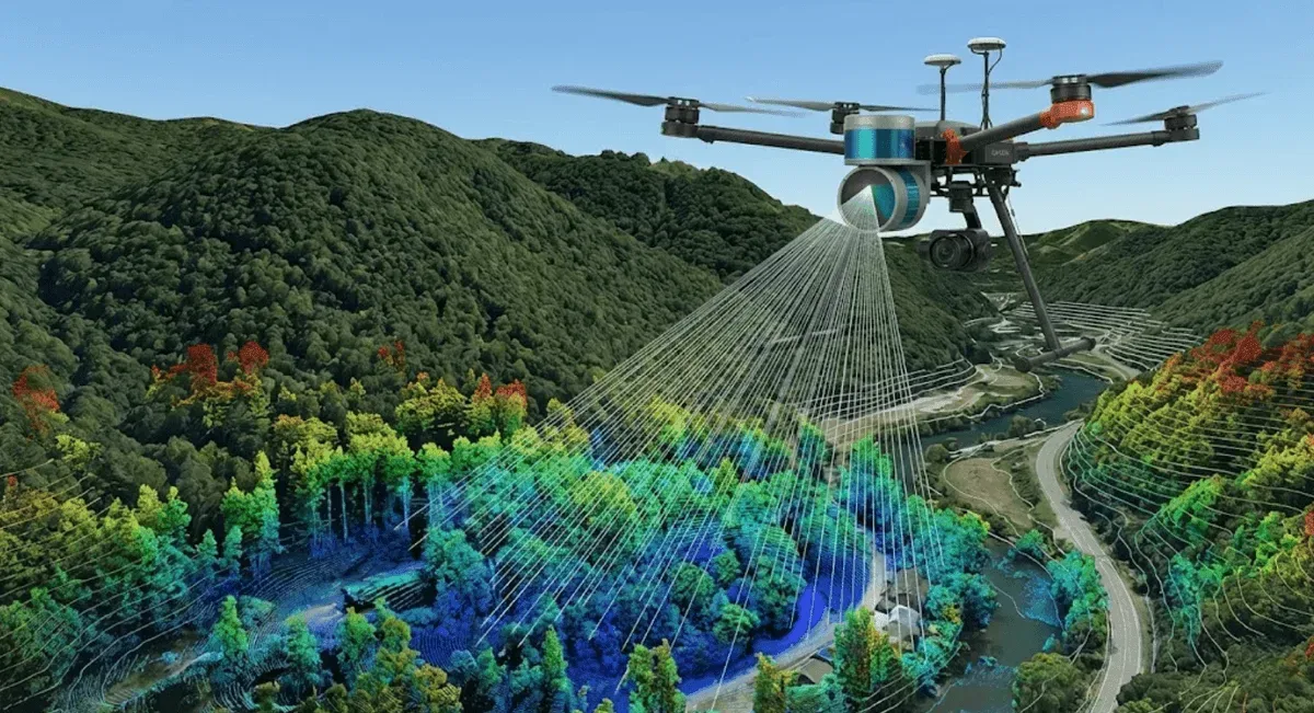
RST Ltd. provides 3D terrain modeling and mapping services, integrating UAV aerial photogrammetry and LiDAR scanning to produce high-density 3D point clouds, Digital Elevation Models (DEM), Digital Surface Models (DSM), and orthophotos, meeting the needs of engineering surveys, earthwork calculations, digital terrain for land consolidation areas, and cultural heritage modeling.
Applicable Scenarios
- Engineering surveys and construction earthwork calculations
- Digital terrain production for land consolidation areas and urban planning
- Volume measurement for mining, earthwork, and stockpiles
- 3D modeling of cultural heritage and structures
Monitoring Methods
- Technologies used: UAV aerial survey services photogrammetry, UAV LiDAR scanning
- Deliverables: high-density point clouds, DEM, DSM, orthophotos, extendable to contour lines, cross-sections, volume calculations, and 3D realistic models
- Accuracy specifications: UAV LiDAR scanning accuracy can reach 2 cm; aerial photography combined with ground control points can also reach centimeter level
- Data formats: can be exported in standard GIS and engineering drafting formats
Comparison with Other Methods
| Item | UAV LiDAR | UAV aerial photography | Traditional manual survey |
|---|---|---|---|
| Vegetation penetration | Can obtain ground surface | Limited | Limited |
| Large-area efficiency | High | High | Low |
| Cost | Medium-high | Low | Depends on scope |
| Best for | Vegetated areas, high accuracy | Bare surfaces, orthophotos | Local high accuracy |
Aerial photography and LiDAR can be chosen or fused depending on site conditions.
Representative Cases
Our services cover numerous engineering survey and digital terrain production projects.
Service Process
- Needs assessment — confirm deliverables, accuracy, and scope
- Aerial survey operations — plan flight routes and deploy ground control points
- Data processing — point cloud processing and modeling, quality control
- Delivery — DEM / DSM / orthophotos and advanced analysis
Get in Touch
Need 3D terrain modeling or mapping? Feel free to contact us.
Frequently Asked Questions
What deliverables does 3D terrain modeling produce?
Standard deliverables include high-density 3D point clouds, Digital Elevation Models (DEM), Digital Surface Models (DSM), and orthophotos, and can be extended as needed to contour maps, cross-sections, earthwork volume calculations, and 3D realistic models.
Should I use UAV aerial photography or LiDAR for modeling?
Aerial photogrammetry is lower in cost and suitable for bare surfaces and large-area orthophotos; UAV LiDAR can penetrate vegetation to obtain true ground elevation, suitable for vegetated areas and high-accuracy terrain. We can choose or fuse the two depending on site conditions.
What modeling accuracy can be achieved?
UAV LiDAR scanning accuracy can reach 2 cm, and aerial photography combined with ground control points can also reach centimeter level. Actual accuracy depends on flight altitude, ground control, and terrain complexity.