InSAR Deformation Monitoring
Services
Service Content
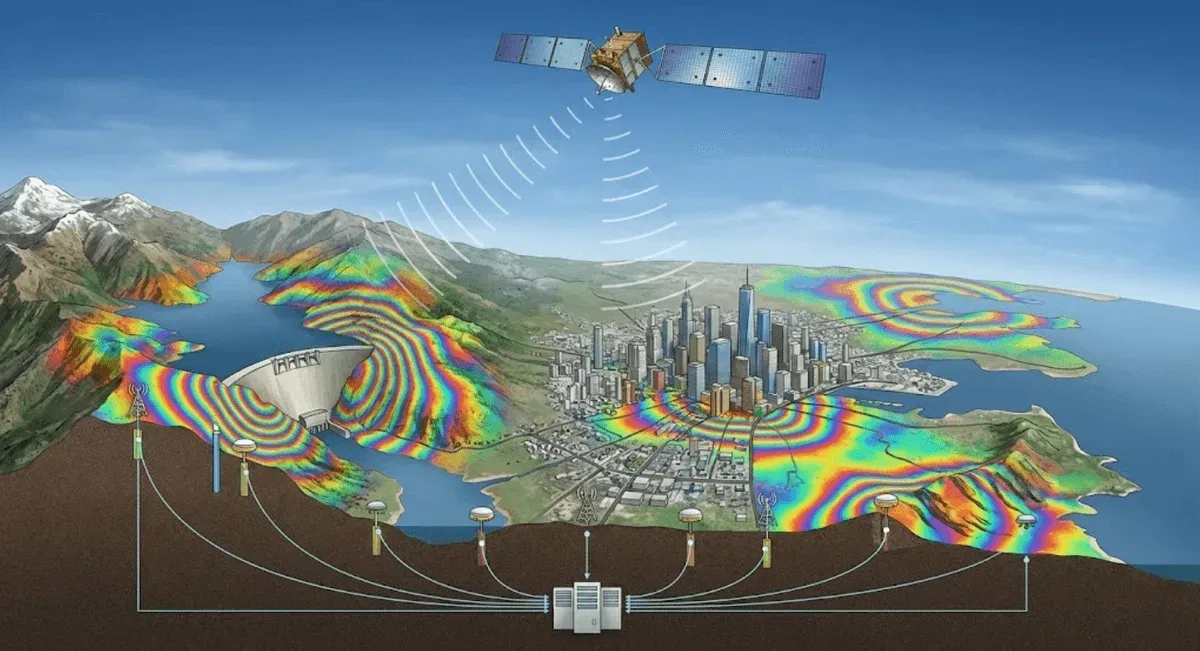
We deliver a complete satellite radar interferometry portfolio spanning three complementary techniques, selected or combined based on project characteristics:
- DInSAR (Differential Interferometric SAR): phase difference between two radar acquisitions for rapid, large-scale event-driven deformation assessment — earthquakes, landslides, and subsidence.
- PS-InSAR (Persistent Scatterer InSAR): time-series analysis of stable reflectors such as buildings and rock surfaces, delivering per-point, millimetre-level long-term deformation history, ideal for urban areas and engineered structures.
- SBAS-InSAR (Small Baseline Subset InSAR): multi-pair small-baseline processing that mitigates decorrelation in vegetated or fast-changing terrain, supporting continuous time series for slopes, mountainous areas, and reservoirs.
All techniques are remote-sensing based, requiring no on-site equipment for long-term, wide-area displacement monitoring.
Main Applications
- Land subsidence monitoring
- Slope stability assessment
- Deformation analysis around mining areas and reservoirs
- Earthquake and volcanic activity monitoring
Technical Advantages
- Large-scale synchronous monitoring
- Millimeter-level precision
- Unaffected by weather conditions
- Historical data retrospective analysis
Frequently Asked Questions
Which satellite radar interferometry techniques does RST Ltd. provide?
We deliver three complementary techniques: DInSAR for rapid large-scale event-driven deformation assessment; PS-InSAR for per-point, millimetre-level long-term time series over stable reflectors such as buildings and rock surfaces (ideal for urban and engineered structures); and SBAS-InSAR, which uses small-baseline multi-pair processing to mitigate decorrelation in vegetated or fast-changing terrain. All three achieve millimetre-level sensitivity over coverage areas of hundreds of square kilometres.
Does InSAR monitoring require on-site equipment installation?
No. DInSAR, PS-InSAR, and SBAS-InSAR are all remote-sensing techniques based on satellite radar imagery. No on-site equipment installation is needed. With satellite radar data of the target area, long-term and wide-area displacement monitoring can be performed.
Can InSAR results be integrated with other monitoring data?
Yes. We regularly integrate InSAR results with GNSS, inclinometer, and other on-site monitoring data. Cross-referencing multiple data sources provides higher-confidence displacement trend assessment and engineering safety recommendations.