Real-Time Slope Monitoring
Services
Service Overview
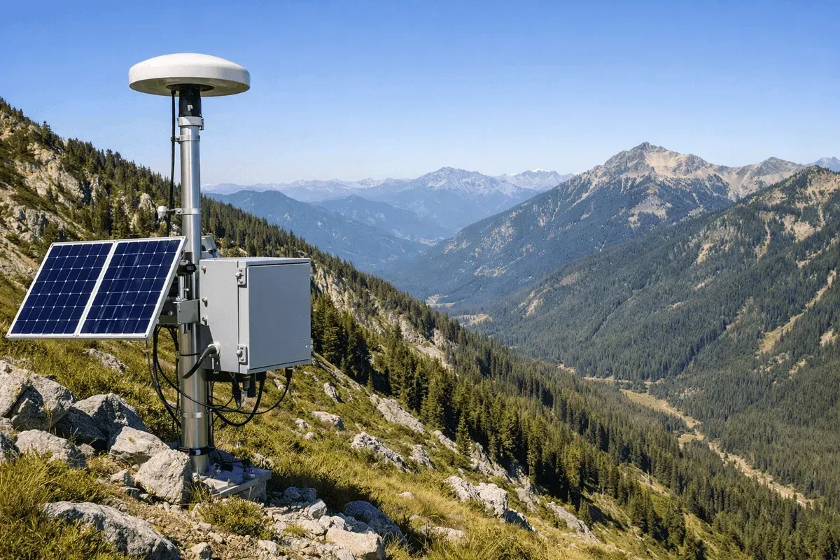
RST Ltd. provides real-time slope monitoring services across all of Taiwan, integrating RTK GNSS, inclinometers, accelerometers, and an AI early warning system to continuously track slope displacement and collapse risk 24 hours a day on the GeoGuard platform. Our clients include government agencies such as the Agency of Rural Development and Soil and Water Conservation and the Directorate General of Highways, as well as engineering consultancies and construction firms.
Applicable Scenarios
- Road slopes and slope faces along highways
- Mountain settlements and slopes behind communities
- Slopes adjacent to engineering excavations and temporary construction slopes
- Natural landslide-prone areas and slopes above protected assets
Monitoring Methods
- Technologies used: RTK GNSS for 3D surface displacement, inclinometers for deep-layer horizontal displacement and sliding surfaces, and accelerometers for vibration and collapse events
- Measurement items: 3D surface displacement, deep-layer displacement profiles, vibration, and tilt, with the option to integrate environmental factors such as rainfall
- Accuracy specifications: GNSS horizontal 1–2 cm, vertical 2–3 cm (actual values depend on site conditions)
- Data transmission and visualization: Sensor data is automatically transmitted 24/7 to the GeoGuard platform for real-time integrated interpretation
Comparison with Other Methods
| Item | This service (GNSS + on-site sensors) | Periodic manual measurement | InSAR wide-area survey |
|---|---|---|---|
| Timeliness | 24-hour continuous, real-time alerts | Periodic, not real-time | Per satellite cycle |
| Accuracy | Centimeter-level (specific points) | Depends on instrument | Millimeter-level (relative) |
| Coverage | Key slopes | Key slopes | Large area |
| Best for | Real-time monitoring of key slopes | Low-risk inspections | Screening prone areas |
In practice, InSAR wide-area surveys are often used to identify hotspots, followed by GNSS real-time monitoring of key slopes—the two methods complement each other.
Representative Cases
Our services cover numerous government-commissioned real-time monitoring projects for road and mountain slopes.
Service Process
- Site assessment — field survey, analysis of sliding modes and protected assets
- Equipment installation — deployment of GNSS, inclinometers, accelerometers, and other sensors
- Real-time monitoring — data transmitted 24/7 to the GeoGuard platform for automated analysis
- Early warning and reporting — tiered alerts, periodic reports, and response recommendations
Get in Touch
Need to evaluate a slope monitoring solution? Feel free to contact us, and our engineering team will provide recommendations and a quotation based on your site conditions.
Frequently Asked Questions
What technologies are typically integrated in real-time slope monitoring?
Based on site conditions, we integrate RTK GNSS (3D surface displacement), inclinometers (deep-layer horizontal displacement and sliding surfaces), and accelerometers (vibration and collapse events), and can combine environmental factors such as rain gauges, with real-time integrated interpretation through the GeoGuard platform.
Should I choose GNSS or InSAR for slope monitoring?
The two are complementary. If you need centimeter-level, 24-hour real-time monitoring of a specific slope, GNSS + on-site sensors is suitable; if you first need to screen prone areas over a wide area and retrieve historical deformation, InSAR is suitable. We often use InSAR wide-area surveys to identify hotspots, then GNSS to monitor key slopes in real time.
How is monitoring data used for real-time notification and early warning?
Sensor data is automatically transmitted 24/7 to the GeoGuard platform, and when preset thresholds are exceeded, alerts are automatically issued via SMS, email, or platform push notifications. The system can also link to government alerts from the Central Weather Administration and the Agency of Rural Development and Soil and Water Conservation, helping management agencies respond in real time.