GeoGuard Data Platform
Services
Platform Overview
GeoGuard is a monitoring data platform developed in-house by RST Ltd. It helps engineering teams consolidate data from GNSS, accelerometers, inclinometers and other sensors in one place, analyze it automatically, and proactively raise alerts — so your monitoring data speaks for itself instead of remaining a pile of raw readings.
Core Features
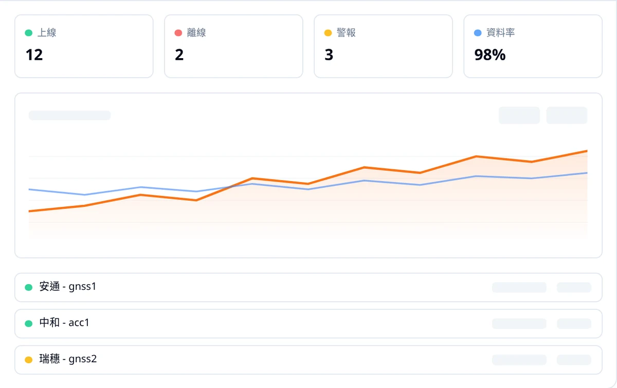
- Real-time data ingestion — Continuous 24/7 reception of data from all sensor types
- Automatic anomaly detection — Automatically flags quality issues, spikes, drift and other events
- Trend analysis & summaries — Current-status summary cards plus clear long-term displacement trends
- AI assistant — Natural-language Q&A, automated monitoring reports, and forecasting of future trends
- Environmental factor integration — Overlays rainfall, space weather and other data to interpret the causes of anomalies
- Government alert linkage — Connects to alerts from the Central Weather Administration, the Rural Development and Soil and Water Conservation Agency, and more
How It Works
- Install equipment — Deploy GNSS, accelerometers, inclinometers and other sensors on site
- Automatic ingestion — Data flows into the platform automatically
- Intelligent analysis — The system detects anomalies, integrates environmental factors and produces trends
- Get reports — View, download, share online, or integrate with your own systems
Platform Advantages
- Local data storage — Self-hosted database; data never leaves the country
- Enterprise-grade security — Encrypted transmission, user permission isolation, multi-project management
- Scalable & flexible — API support to integrate with existing systems and workflows
Use Cases
- Real-time monitoring management for large engineering projects
- Integration of distributed, multi-point sensor networks
- Long-term structural health monitoring databases
- Disaster early warning and emergency-response decision support
- Automated generation of engineering safety reports
Plans
- Basic — Unlimited monitoring sites, basic alerts, 5 users
- Professional — CSV export, AI reports, trend forecasting, 10 custom alert rules
- Enterprise — Unlimited custom alerts, government alert integration, custom development and local support
For a full plan comparison and a trial, please visit the platform homepage.
Frequently Asked Questions
What types of sensors can GeoGuard platform integrate?
GeoGuard platform supports integration of data from GNSS, accelerometers, inclinometers, and various other monitoring sensors. With unified data formats and API interfaces, it can also integrate with third-party systems to create a complete monitoring ecosystem.
How is GeoGuard platform accessed? Is software installation required?
GeoGuard is cloud-deployed and accessible anytime, anywhere through a web browser without any software installation. The platform features an intuitive interface and supports customizable dashboards tailored to project-specific monitoring needs.
How secure is the GeoGuard platform data?
GeoGuard platform uses encrypted transmission and automatic backup mechanisms to protect monitoring data. Deployed on high-reliability infrastructure such as Cloudflare, it ensures service stability and data security, with user permission management for access control.