InSAR Satellite Radar Deformation Analysis
Services
Service Overview
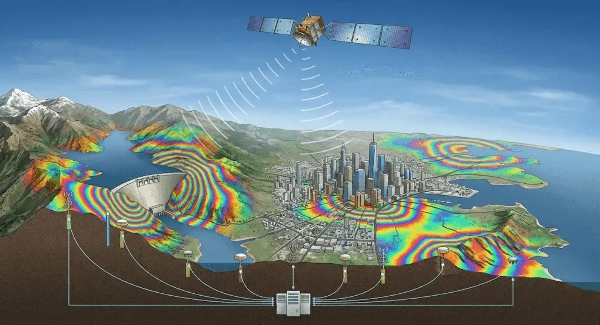
RST Ltd. provides a complete InSAR satellite radar deformation analysis service, integrating three techniques—DInSAR, PS-InSAR, and SBAS-InSAR—to detect surface deformation at the millimeter level, covering hundreds of square kilometers without installing any on-site equipment. It is suitable for wide-area monitoring of large-scale collapses, land subsidence, urban settlement, and dam slopes.
Applicable Scenarios
- Wide-area surveys of large-scale collapses and landslide-prone areas
- Land subsidence and urban settlement monitoring
- Deformation of dams, reservoirs, and surrounding slopes
- Surface deformation around mining areas, excavations, and infrastructure
Monitoring Methods
- DInSAR: well-suited to rapid assessment of large-area, event-driven deformation
- PS-InSAR: provides point-by-point, millimeter-level long-term time series over stable reflectors such as buildings and rock surfaces, ideal for urban areas and structures
- SBAS-InSAR: uses small-baseline multi-pair processing to reduce decorrelation, suitable for vegetated areas or regions with drastic terrain change
- Data transmission and visualization: Results are presented as deformation rate maps and time-series curves, and can be integrated with on-site data such as GNSS and inclinometers on the GeoGuard platform
Comparison of the Three Methods
| Method | Applicable area | Required imagery | Deformation type | Computation cost |
|---|---|---|---|---|
| DInSAR | Large bare surfaces | Few | Event-driven, large magnitude | Low |
| PS-InSAR | Urban areas, rock, structures | Multiple acquisitions | Long-term, slow, point by point | High |
| SBAS-InSAR | Vegetation, drastic terrain change | Multiple acquisitions | Long-term, area-based | High |
Representative Cases
Our services cover numerous government-commissioned satellite radar deformation analysis projects.
Service Process
- Needs assessment — confirm the monitoring area, deformation type, and applicable method
- Image processing — interferometric processing, time-series analysis, and quality control
- Deliverables — deformation rate maps, time-series curves, and hotspot analysis
- Integration and verification — cross-checking with on-site monitoring data
Get in Touch
Need InSAR deformation analysis? Feel free to contact us.
Frequently Asked Questions
What InSAR analysis methods does RST Ltd. provide?
We provide three complementary methods—DInSAR, PS-InSAR, and SBAS-InSAR: DInSAR is suited to rapid assessment of large-area, event-driven deformation; PS-InSAR provides point-by-point, millimeter-level long-term time series over stable reflectors; and SBAS-InSAR uses small baselines to reduce decorrelation, suitable for vegetated areas or regions with drastic terrain change.
Does InSAR analysis require on-site equipment?
No. InSAR is a remote-sensing technique using satellite radar imagery; analysis can be performed once imagery of the target area is acquired, with no on-site equipment installation, and historical imagery can be retrieved for long-term deformation analysis.
How is the reliability of InSAR results verified?
We often cross-check InSAR results against on-site monitoring data such as GNSS, leveling, or inclinometers, using multi-source data verification to improve the reliability of deformation trend assessment and its value for engineering interpretation.